Tag Archives: places

The Origins of Infrastructure

One of the great mysteries of humanity’s history is how we made the transition from an isolated, emergent species to attain today’s globally dominant civilization. Scientists tell us that the story began as early as 7 million years ago in Eastern Africa. Fossils found in the Awash Valley give evidence of our early precursors. Archaeological findings suggest that some of these precursors began to fabricate and use rudimentary stone tools between 6 million and 2 million years ago. Learning to control fire followed about 1 million years ago. By 70,000 years ago homonins had migrated out of Africa and begun to apply more complex technology evidenced in hafted spears, for which a sharpened stone point was attached to the wooden shaft.

The fossil record indicates that our own species, Homo sapiens, evolved during this progression and became the sole survivor among several homonin species. The evolution included a remarkable growth in brain size as well as emergence of social behavior and technological prowess. Some scientists hypothesize an interaction between physical capability and intellectual accomplishment to explain this evolution.

British archeologist Steven Mithen, for example, surmises that early uses of technology (such as hafting of spears) encouraged development of “cognitive fluidity,” an ability to abstract and combine aspects of experience from different domains such as finding shelter or observing game.  The large brain of Homo sapiens was an essential adaptation that enabled this cognitive fluidity to develop, but does not by itself explain how the development came to be. Adopting and using a cultural innovation provides the stimulus for users to extract more from their brains than they might have otherwise.

Drawing on observations of ants and other animals that exhibit eusocial behavior and altruism—in which some individuals in a colony or nest limit their own reproductive potential by raising the offspring of other nest-mates or defending the group against competitors and predators—noted Harvard biologist Edward Wilson suggests that certain “preadaptations” favor the behaviors’ evolutionary development. Among the most important of these preadaptations, Wilson conjectures, is a species’ propensity for living in defensible nests.  When early humans, tribal by nature, learned to use fire and establish campsites sufficiently persistent to be guarded as a refuge, they had taken a crucial step toward modern social organization.

Wilson and his colleagues Martin Nowak and Corina Tarnita assert that the advantage of a defensible nest located within reach of reliable food sources, particularly one requiring greater energy in its construction, is a crucial causative agent in the evolutionary development of eusociality, a trait that loosely applies to humans as well as ants. A next step in humans’ social evolution beyond the adoption of movable campsites would logically seem to be long-term commitment to a fixed location. The earliest evidence of such commitment arguably is found in the Chauvet Cave walls in southern France.  Images painted on the cave walls here and elsewhere (for example, the El Castillo cave in Cantabria, Spain, and others Romania and Australia) are estimated by various archeologists and methods be 28,000 to 40,000 years old.

We have no convincing evidence of the creators’ motivations for any of the cave paintings, but their permanence and often difficult-to-access locations suggest these were not simply decorations of living space, but rather demonstrations of a particular significance of place, perhaps an effort to preserve human memory as recorded history. I propose that in this sense these ancient markings are humanity’s earliest known infrastructure.

University of Cambridge archaeologist Graeme Barker has presented the evidence suggesting that the domestication of various forms of plants and animals evolved in separate locations worldwide, starting around 12,000 to 14,000 years ago.  For many researchers, this domestication is synonymous with “agriculture,” a technological innovation and foundation of modern civilization.  An alternate model proposed by David Rindos in the 1980s proposed that domestication of locally available plants, a co-evolutionary interaction of humans and their food sources, led to intentional agriculture and consequent selection of preferred species and strains.

This domestication of plants has been characterized as the beginning of the Neolithic or Agricultural Revolution.  Evidence, particularly from the Fertile Crescent region in the Middle East, indicates that cultivation was accompanied by construction of settlements and drainage ditches and landforms to control plant irrigation.  Archeological studies by Harvard archeologist Ofer Bar-Yosef and others are currently thought to indicate that the Natufian culture in the region is the world’s oldest example of sedentary settlements and agriculture, notable particularly because the settlements may have preceded the commencement of crop cultivation.

Whether development of agriculture preceded or followed the birth of cities has long been debated.  Mithan, for example, reflecting recently on the progress of human civilization, expressed a widely held view that agriculture came first, and once farming had originated, towns and cities appear to be an almost inevitable consequence.  On the other hand, Jane Jacobs, an economist and unabashed urbanist, famously argued in the 1970s that labor specialization and trade first gave rise to cities, and that feeding their populations necessitated the development of agriculture. (Archaeologists notably disagree. See Smith, Michael E., Jason Ur, and Gary M. Feinman.  2014.    “Jane Jacobs’s ‘Cities-First’ Model and Archaeological Reality.” International Journal of Urban and Regional Research 38 (4): 1525-1535.)

In either case, however, it would seem that infrastructure came first. The investment of effort in clearing fields; moving earth to adjust water flow; building fences, protective walls, and substantial shelters; maintaining paths for transportation; and the like would have contributed substantially to agricultural productivity, settlement economy, and social functioning of the residents.

Infrastructure principles to live by

As a child fascinated by tales of exploration and archeology of the artifacts of Egyptian, Greek, Roman, and Incan civilizations, I built models of balsa-wood and modeling clay to recreate in my room the temples and fortresses pictured in my books.  I channeled my university studies toward building things, the bigger the better, I thought, as my training progressed.  In graduate school I encountered Albert O. Hirschman, a Harvard economist whose seminal  book introduced me to the ideas of social overhead capital—the etymological precursor of what we mean today by economic or societal infrastructure—and its essential role in economic development. (1958, The Strategy of Economic Development, New Haven: Yale University Press)  I wrote a doctoral dissertation on “systems of constructed facilities,” and from there moved on to planning and design of new cities, airports, highways, and investment policy.  I guess it is fair to say I have been interested in infrastructure for a while, and maybe a wonk on the subject.

In any case, I was excited by the opportunity in 1992 to work with a National Research Council committee seeking to gain an understanding of what might be done to address the problems underlying the nation’s increasingly distressing instances of infrastructure inadequacy, failure, collapse, and destruction.  The group spent more than a year talking to people from cities around the country and extracting from their experience a set of three broad principles for acting locally to address what were agreed to be national and even global problems. (The committee’s report was published as In Our Own Backyard: Principles for Effective Improvement of the Nation’s Infrastructure, 1993; Washington, DC: National Academies Press)

The principles themselves are fairly straightforward, albeit cryptic: (1) Geography matters. (2) The paradigm is broadening. (3) Value the “public” in public works.

My interpretation has perhaps shifted in the years since we wrote the report.  First, infrastructure should be tailored to the specific physical, environmental, social, and economic characteristics of the area to be served.  However, these various characteristics are connected in complex ways that make the tailoring difficult, and we need good data to achieve a good fit.  Second, all infrastructure has to be understood as providing multiple services, having not just a single function.  Thinking that our highways simply let us move from place to place and water systems only provide a clean supply when we turn the tap is—pardon the possible pun—tunnel vision; we need to broaden our perspectives in funding, designing, and operating each piece of infrastructure and address the system the pieces comprise.  Third, the public is a part of the infrastructure, not simply a customer, investor, or impediment. We as a society and our infrastructure are engaged in an evolving dialogue; the better we understand our role in that evolution, the more likely it is that future generations will appreciate the legacy of our infrastructure investment.

Two decades later, I think these principles are still relevant and important.  They are also, unfortunately, no more representative of current practice than they were when written.

(A footnote:  In the course of earlier work for the National Research Council, I found that the word “infrastructure” itself was hardly used at all before 1980. (For example, see Infrastructure for the 21st Century: Framework for a Research Agenda, 1987.) Typing it into Google’s search field today returns some 270 million hits.  “Social overhead capital,” has not caught on with the Internet public, showing up not quite 8.1 million times.  “Principles of infrastructure” returns some 1.82 million hits. Narrowing down to “principles of economic infrastructure” yields 315,000; replace “economic” with “societal” and you drop to just over 9,000.  For comparison, “ten commandments” gets 4.4 million hits and “principles to live by” 820,000!)

Baltimore’s Sustainability Report

Baltimore’s Mayor Stephanie Rawlings-Blake on April 16, 2011, stood up at the city’s Druid Hill Park Conservatory to announce the release of the 2010 Annual Sustainability Report.  This yearly accountability tool to track Baltimore’s progress toward improving economic, social, and environmental sustainability was the city’s second such report, a product of the Baltimore Office of Sustainability.

Baltimore defines sustainability as “meeting the current environmental, social, and economic needs of our community without compromising the ability of future generations to meet these needs.” This is deceptively similar to the often quoted formulation of the United Nations Brundtland Commission.  Our Common Future, that Commission’s 1987 report, asserted that “Sustainable development is development that meets the needs of the present without compromising the ability of future generations to meet their own needs.”  The concept of needs was explained with particular priority of concern for the world’s poor.  Our ability to meet needs was represented as limited by our social organization and technology as well as environmental constraints.

Read literally, Baltimore’s idea of sustainability differs in two possibly controversial ways from conventional usage. First, development–meaning steady increase of living standards and economic activity–is not mentioned.  Second, the needs that future generations will want to meet seemingly are presumed not to differ from ours today. But perhaps, for Baltimore’s sustainability assessors, development is a fundamental need.

Baltimore’s sustainability goals

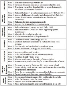
In any case, the report is structured around 29 specific goals in seven clusters aimed at enhancing the city’s sustainability. Some of the goals are quite specific (for example, reducing greenhouse gas emissions by 15% by 2015), but most are open ended.  And with the possible exception of supporting local business, every goal is crucially linked to the region’s public works infrastructure, although infrastructure is cited explicitly as a contributing resource for only about one-third.

By 2022, the Baltimore Office of Sustainability had issued a total of 9 annual reports and a 2019 Baltimore Sustainability Plan. The city’s website concludes, “Sustainability is about strengthening our city through collaborative action. It’s about balancing social equity, economic growth, and environmental action. It’s about the need for justice, equity, inclusion and diversity in everything we do — recognizing that these are absolutely imperative to combating the challenges we face.”

No Little Plans: The Dream of Abuja

Infrastructure provides an armature for urban development, and nowhere is this more apparent than in Abuja.  Nigeria’s dynamic and restless capital city, now the home of some 800,000 people and maybe more than a million, sprang from the bush barely just over three decades ago. As the nation settled down from a civil war and ten years of military rule, the young constitutional government resolved to build a new city in the middle of the country.  An international competition was held to select planners for the then-nameless capital. An American consortium won. In 1979, the master plan was published.  (Disclosure: I was a member of the core group of International Planning Associates professionals and subsequently Chief Planner for PRC (Planning Research Corporation) Nigeria.)

The new city—the name Abuja, originating as a 19th-Century emirate, was transferred from a small city now called Suleja, just to the north—was to be centrally positioned and ethnically neutral in a nation of diverse tribal identities, a showcase for national unity and modern African
urban development.  The underlying concepts were hardly revolutionary: Washington, DC, and many state capitals in the United States, for example, as well as Brasilia and St. Petersburg (Russia) had similar origins. In addition Lagos, the capital at the time, had grown beyond the capacity of its infrastructure; the city’s often chaotic services and gridlocked traffic threatened to choke the nation’s development.

Aso Rock would be the capital's backdrop

The desire for Abuja to provide a strong image and sense of place, representing Nigeria’s position as the most populous nation in Africa and a rising democratic force in the continent were decisive in the mater plan’s development.  As the capital, Abuja would have symbolic as well as political and economic importance.  The siting of major government buildings and the layout of the transportation networks were intended to take advantage of dramatic topography and provide the matrix for a centralized urban form easily served by transit.

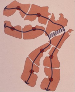
Transit spines and modular urban expansion areas

The plan’s curvilinear form was meant to serve the requirements for water supply and drainage by following the contour of the site in the shallow basin bounded by the Aso Rock and its surrounding hills. Parallel central transit spines and peripheral highways were planned to provide a framework for modular residential and commercial “mini-cities” that would be developed outward from the urban core as needed, each accommodating between 75,000 and 200,000 people and a full range of schools, healthcare, recreation, and other community services.  The program for residential land and housing sought to balance the government’s desire for high living standards for its citizens and the planners’ projections of incomes and affordability within an advancing but still relatively
less-developed economy.   With a government-set target population of 1.6 million by the year 2000 and 3 million ultimately, Abuja was planned be the largest free-standing new city ever built.  The federal government was to move from Lagos to Abuja by 1986.

It has been written that Daniel Burnham said, “Make no little plans. They have no magic to stir men’s blood and probably will not themselves be realized.”  Certainly Abuja’s master plan qualified as a grand scheme able to generate a certain excitement.  While government functions would be the principal foundation for the city’s economy, the plan represented substantial private-sector investment opportunity and, to use developers’ vernacular, the numbers worked. However, speaking at the American Association for the Advancement of Science annual meeting in Houston in 1978, I noted it would not be easy.  Threats to success could be foreseen in potential shortages of construction materials and labor, congestion of the poorly developed transportation network in Nigeria’s Middle Belt region, management challenges associated with such a large-scale undertaking, and the need for steadfast government support of the enterprise.

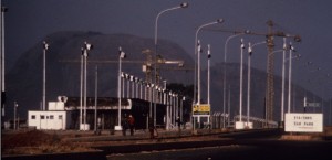
Early construction at Abuja, 1985

As it turned out, in the early stages of development some large buildings were constructed in advance of supporting infrastructure, so that government ministry workers in the early years labored under much-less-than-ideal conditions. The official shift of the capital to Abuja did
not occur until 1991.  The Nigerian press reports that electricity, sewer, and telecommunications systems continue to be problematic. Housing and land use have remained sources of continuous conflict over the years, with the master plan cited variously as a myth used to justify forcible evictions of lawful residents and a neglected guide for balanced growth.  (See, for example, a 2008 report from the Centre on Housing Rights and Evictions.)

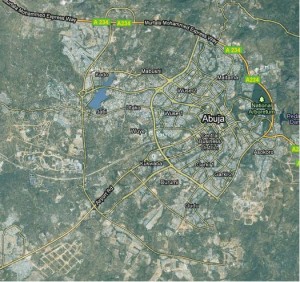
Satellite view of Abuja, 2010 (Google Earth)

Scottish poet Robert Burns wrote, “The best laid schemes o’ Mice an’ Men, Gang aft agley….” (To a Mouse, 1785)  The thought is a suitable caution to Burnham’s successors.

Measuring Infrastructure Performance Is Complex

Performance is the execution of a task or fulfillment of a promise or claim. Musicians give a good performance when they play well, provide listeners with insights to the meaning and emotion behind the music, and entertain their audiences. Employees of large companies have annual performance reviews to reflect on how well they and their immediate supervisors think they are doing their jobs.
For civil infrastructure, performance has something to do with moving people and goods, supplying water, removing wastes, and keeping us comfortable. However, just as we might disagree about whether a singer has given a good performance, individual infrastructure users, companies that depend on infrastructure, government agencies that build it, people who live near the facilities, and others may have their own ideas about both what is the task or promise the infrastructure should fulfill and how well the job is being done. Because these several groups all play a role in shaping our infrastructure, determining how it is used, and taking advantage of the services (or disservices, as some might say) delivered, we often refer to them as stakeholders.
These stakeholders are a wonderfully diverse bunch and their ideas are dynamic. Trying to understanding what might be meant by “good performance” for infrastructure gets complicated. The U. S. Army Corps of Engineers in the 1950s and ‘60s built the Buford Dam and others along the Chattahoochee River for power generation, flood control, and navigation purposes. Lake Lanier, a large reservoirs created near Atlanta, Georgia, became an important part of that growing region’s water supply as well as a popular recreation area. Downstream, where the river joins with others rolling south toward the Gulf of Mexico, oyster harvests in Apalachicola Bay depend on the freshwater flows. The states of Alabama, Florida, and Georgia have feuded for decades over the water management in the river basins. Since construction of the Buford Dam and Lake Lanier was completed in 1957, the tasks they are expected to perform have certainly shifted.
Sometimes stakeholders are very direct in stating the broader objectives they have in mind. Public works investments during Franklin Roosevelt’s “New Deal” era, for example, were planned to give jobs to some of the legions of people left unemployed by the Great Depression as well as to provide the services of municipal buildings and libraries. Huge water projects built in the vast and largely empty southwestern areas of the United States were intended to enable settlement and consolidate the nation’s hold on land which (to quote Robert Frost’s famous poem, The Gift Outright) “was ours before we were the land’s.” The spending of public funds on new roads and water mains is routinely justified by expected gains in property values and subsequent tax revenues expected when newly accessible and serviced land is developed.
Sometimes our objectives are less overt. Some highways built in urban centers during the 1950s and ‘60s were viewed by their planners as instruments of slum clearance as well as transportation arteries. Public backlash gave rise to more general resistance to new construction and the term NIMBY—“Not in my back yard!”—that has since come to be recognized in many languages. A recent Saint Index© survey of U.S. attitudes about real estate projects and development found that our extended economic downturn may be softening opposition to new development in general, 74 percent of American adults still do not want it in their own community.
Sometimes we simply have too narrow a perspective. Vitruvius, the 1st Century BC Roman who gave us the 10-book De Architectura, wrote famously that our infrastructure should not only ward off hostile attack, glorify the gods, and enhance public convenience, but should do so with “strength, utility, grace.” A panel of experts convened by the National Academy of Sciences to consider principles for improving the nation’s infrastructure (full disclosure: I served as the staff support and a primary report author-editor) asserted that we must manage our infrastructure to “… incorporate effective recognition of infrastructure as a multimodal and multipurpose system—a stream of services—as well as an armature of community development.” In other words, no infrastructure should be conceived of as doing only one thing.
In any case, whether the objectives, promises, or claims are narrowly or broadly conceived, explicitly or implicitly stated, the performance of infrastructure as a public investment must be judged by how well it serves the community. Measuring the return on investment will always be complicated.

Flying Over Batam—Infrastructure of a New City and its Economic Development

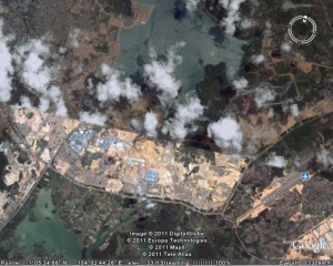
I used Google Earth to visit Batam Island in Indonesia last week.  The trip was certainly easier than the nearly 24 hours of flying and layovers required when I made the trip from Washington two decades ago, and the view from above was an exciting indication of changes on the island.  But it was no substitute for being there in person.

Batam Centre in 2011, as viewed with Google Earth.

Google Earth view of Batam Centre, 2011

I spent Christmas of 1983 with a band of like-minded planners and architects on Batam Island.  The rooms that we occupied were converted shipping containers, at one of the few hotels available.  The power went out on Christmas Eve, an almost daily occurrence, as we gathered with flashlights and candles in one room to open a few gifts thoughtfully provided by our colleagues back home.  With the tropical rain pouring down, we turned in early to be ready for the big day to come.

The story started a year earlier.  Planning Research Corporation was engaged by the Batam Industrial Development Authority (BIDA), then part of Indonesia’s Ministry of Technology, to prepare a master plan for Batam Centre.  (British spelling seemed to be the norm for English usage in Indonesia.)  We were teamed with an Indonesian firm, P. T. Atelier 6.  Prof. Dr. Eng. B. J. Habibie, Minister of Technology and Chairman of BIDA, was determined that Batam should be a free-trade enclave and focus for economic development as part of the Straits of Malacca (Singapore Straits) region.  (Habibie, who later became the president of Indonesia, continues to influence the island’s development.) The governments of Singapore and Indonesia had agreed to cooperate.

Batam, on the Malacca Strait (Singapore Strait)

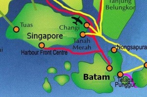
Batam's location, near Singapore

Batam is located about 20 km southeast of Singapore, a short hydrofoil ride from that high-tech island nation.. Batam Centre was to be the administrative and commercial core of the island, a thoroughly modern enclave that would be a comfortable entry for foreign investors and an attraction for vacationers seeking a taste of Indonesia’s rich and colorful culture. As project manager and team leader, I was determined that the plan should be a practical roadmap and model for improved living standards in a growing economy as well as a resource for marketing a nation.

We conducted the usual economic analyses and demographic studies to project plausible population and income scenarios for the island and our emerging concepts of the new city’s role in the region.  We extracted organizing principles from lessons learned about traditional villages and urban form, the social structure of Indonesia’s communities and neighborhoods, and the layers of government established to provide infrastructure and social services.  We studied the topography, soils, hydrology, flora and fauna to understand the environmental opportunities and constraints that should shape development. 

We thought about the educational and training requirements to produce a workforce to be employed by the businesses that might be attracted to Batam.  We projected the demand for housing, schools and health care facilities, transportation, water, power, and waste management.  We prepared tables of numbers, maps, sketches, and models.  Batam Centre—an imagined place on the shores of Tering Bay, covered in mangrove and other tropical vegetation—began to assume for us all what I have come to call a “texture of credibility.”

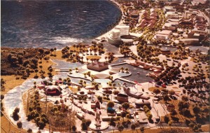
Illustrative model of the Batam Centre plan

Batam Centre, planned on the shore of Tering Bay

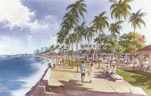
Rendering of view along Tering Bay in the Batam Centre master plan

"Dreaming in the daytime" on the waterfront in Batam Centre

We shipped our maps, drawings, models, and key members of our team to the island.  On Christmas Day we presented our 20-year plan to President Soeharto and his cabinet ministers.  When one of the senior officials told me the plan seemed “very Indonesian,” I was pleased.  Another told me we had helped them to “dream in the daytime.”

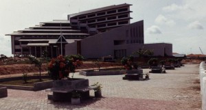
Batam visitors' center, 1991

Batam visitors' center, 1991

Scottish poet Robert Burns, wrote, “The best-laid schemes o’ mice an ‘men gang aft agley,” and so it was with our own scheme to continue working with BIDA to implement our Batam ideas.  By May of 1984 our work was finished, left for others to consider.  I was invited back in 1991 to review progress.  Major roads were in place and our plan was displayed in the visitors’ center BIDA had constructed on the site we had proposed. 

According to official statistics, Batam’s population today has grown about 50% from when we began our planning, to about 990,000.  There are now 66 hotels and beach resorts on the island, with 5,600 rooms available.  Foreign visitors to Batam average 100,000 monthly.  BIDA is responsible for development in the BARELANG region, the three islands of Batam, Rempang, and Galang, now joined by new highway bridges, one of Indonesia’s designated “national development engines.” 

Perhaps it was chance, but I prefer to believe that the physical, social, and economic framework our team laid out 20 years ago has served its purpose as an infrastructure for Batam Centre’s development.  If my satellite-enabled flyover is to be believed, the texture of credibility is becoming a reality.